Why undertake Flood Management Studies?
Flood modelling is a predictive science and is based largely upon probability in determining estimated flood levels.
Council is constantly looking at improved ways to manage flooding and the floodplains across the LGA with the assistance of the Floodplain Risk Management Advisory Committee and Department of Primary Industry and Environment.
Studies and management plans help us make informed decisions about reducing flood risk to the community and to existing and future development, and reduce losses through a range of property, flood and response modification measures.
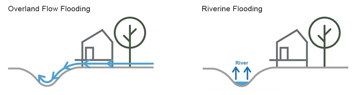
Types of flooding
There are two types of flooding, overland and riverine. Riverine flooding, as the name suggests, relates to flooding of a river or a creek system. Overland flow flooding is caused by intense rainfall events, which result in flow paths forming on sloped areas or floodwater pooling in low-lying flatter areas.
Current Flood Management Studies
| Current Studies | Consultant | Stage |
|---|---|---|
| Uranquinty Levee feasibility and Design | Royal Haskoning DHV | Preliminary Design |
| Glenfield Drain Flood Mitigation Options | Lyall and Associates | Assessment and Modelling |
| Lake Albert Flood Mitigaiton Options | Stantec | Assessment and Modelling |
| North Wagga Flood Mitigation Options | CIE | Analysis and Consultation |
| Humula and Mangoplah Flood Studies | WMA Water | Data Gathering |
| Levee Pump Augmentation Scheme | Stantec | Assessment and Modelling |