Wagga Wagga Major Overland Flow Floodplain Risk Management Study and Plan (MOFFS)
The Wagga Wagga Major Overland Flow Floodplain Risk Management Study and Plan (FRMS&P), which follows on from the Wagga Wagga Major Overland Flow Model Update Report, has been undertaken in accordance with the NSW Government’s Flood Prone Land Policy. This study provides recommendations for reducing flood risk due to overland flooding in Wagga Wagga.
This was first identified in 2011 through the Wagga Wagga Major OverlandFlow Flood Study which developed a model that has been thoroughly reviewed and revised in accordance with best practice in the interim.
In this study, a full assessment of the existing flood risk in the catchment has been carried out, including flood hazard across the study area, over floor flooding of residential, commercial, and industrial properties, identification of known flooding issues and hotspots, and emergency response during a flood event.
This study comprises stages 3 to 4 in the five-stage process outlined in the NSW Government’s Floodplain Development Manual (FDM, 2005) (DIPNR, 2007).
These works include:
- Data collection – collection of all applicable data to be used for the ensuing stages of the studies;
- Flood Study – a comprehensive technical investigation of flood behaviour that provides the main technical foundation for the development of a robust floodplain risk management plan;
- Floodplain Risk Management Study (FRMS) – assess the impacts of floods on the existing and future community and allows the identification of management measures to treat flood risk;
- Floodplain Risk Management Plan (FRMP) – outlines a range of measures, for future implementation, to manage existing, future and residual flood risk effectively and efficiently; and
- Plan Implementation – once the management plan is adopted, an implementation strategy (devised in Stage 4) is followed to stage components dependent on funding availability.
Following the completion of the FRMP Council will begin implementing its recommended measures and will review the plan periodically.
Various measures aimed at managing this flood risk were assessed for their efficacy across a range of criteria. The options were rated according to a detailed matrix of possible impacts. Those rated highest have been recommended in the Floodplain Risk Management Plan, and prioritised based upon how readily the management measures can be implemented, their capital cost, what constraints exist and how effective the measures are.
Measures with little cost that can readily be implemented, and which are effective in reducing damage or personal danger would have high priority.
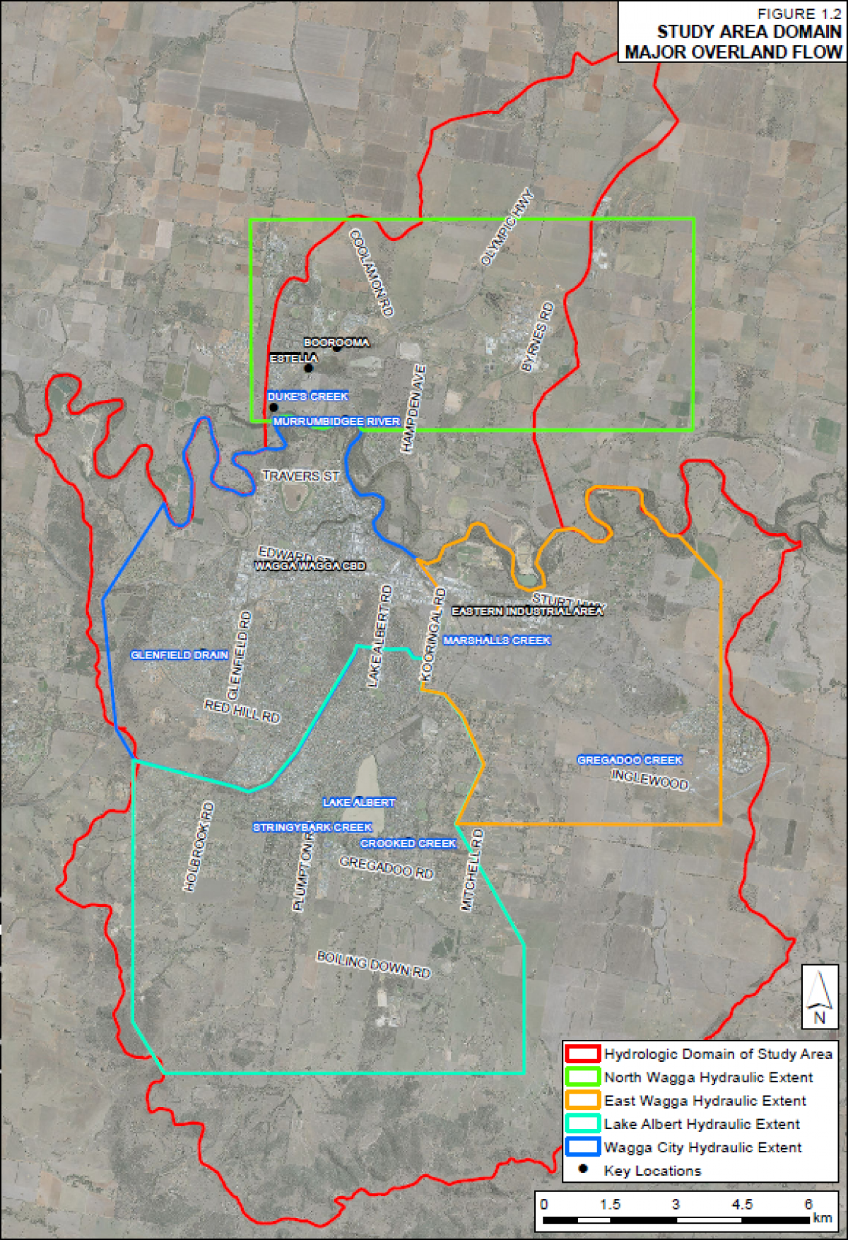
The area considered in the Wagga Wagga Major Overland Flow Floodplain Risk Management Study incorporates catchments with an area of 233 km² and a hydraulic modelling extent of 167 km² both south and north of the Murrumbidgee River.
Study area
Wagga Wagga Major Overland Flow Floodplain Risk Management Study and Plan (MOFFS)
2021 MOFFS - Figures 1-1 - Area of Study Map 738.5 KB Download
2021 MOFFS - Figures 1-2 to 1-19 48.1 MB Download
2021 MOFFS - Figures 2 to 3 7.4 MB Download
2021 MOFFS - Figures 4 to 5 29.6 MB Download
FAQs
Wagga Wagga City Council are primarily responsible for managing flood prone land through the implementation of floodplain risk management strategies. As part of this responsibility, Council has enlisted WMAwater to prepare the Draft Wagga Wagga Major Overland Flow Floodplain Risk Management Study and Plan (MOFFS).
This report outlines the existing and future overland flow flood behaviour in the Wagga Wagga area. It uses the most up to date information and modelling techniques, informed by previous engagement with local residents, to determine overland flow flooding in the catchment.
The study looks at the existing flood environment and the economic impact of flooding and makes recommendations to minimise the future impacts of overland flow flooding in Wagga Wagga’s catchment areas.
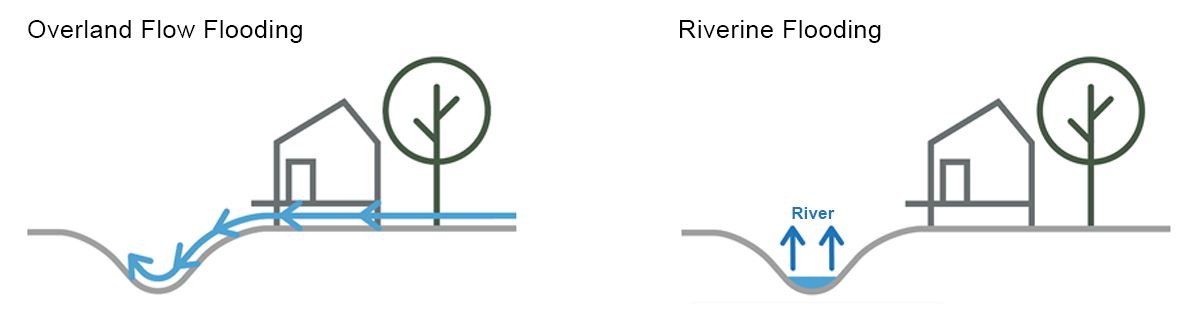
Note that riverine flooding from the Murrumbidgee River is not assessed in this Study. For information on riverine flooding and mitigation measures please refer to the Riverine Flooding page.
Overland flow flooding is caused by intense rainfall events, which result in flow paths forming on sloped areas or floodwater pooling in low-lying flatter areas. Water naturally flows to the lowest point, generally ending up in a creek or a drain. Overland flow paths are the routes taken by rainfall runoff and are not always obvious until they flood.
The Probable Maximum Flood (PMF) is the largest flood that can occur. It is very rare.
All land inundated under the PMF is considered to be flood prone land.
The Flood Planning Level (FPL) is the height used to set floor levels for houses in flood prone areas. It is defined as the “1% AEP flood level” plus an appropriate freeboard (see explanation of ‘freeboard’ below). It is used for planning purposes, and land below the FPL is considered to be flood affected and therefore subject to flood related development controls.
The FPL can be calculated as:FPL = 1% AEP flood level + freeboard (typically 0.5m)
A Freeboard is included in the Flood Planning Level as a buffer, to account for factors such as unforeseen blockages, waves from vehicles (such as SES rescue trucks), other localised hydraulic effects and uncertainties in the modelling and determination of flood levels.
Freeboard is typically 0.5m above a flood level, or for some areas of shallow flood depths a reduced freeboard of 0.3m may apply.
A 1% Annual Exceedance Probability flood event is equivalent to a 1-in-100 year flood, which is a major rain event that occurs on average once every 100 years (i.e. there is a 1% chance of a flood this size or larger occurring at a particular location in any given year). A 2% AEP could occur once every 50 years, a 5% could occur once every 20 years and so on.
The study area is located completely within the Wagga Wagga Local Government Area.
The area incorporates catchments with an area of 233 km2 and a hydraulic modelling extent of 167 km2 both south and north of the Murrumbidgee River.
A map of the area covered is shown in Figure 1.1.
For most people, there is nothing to do in response to this flood study as there is no immediate change to the situation. However, property owners who are planning redevelopment of their property may need to take some additional steps as part of the consent process because flood related development controls may apply. This could include the requirement to have the floor levels of new residential development set at or above the Flood Planning Level.
If there is significant rain at the top of the hill, the rain will run downhill through low lying gullies, channels and surface depressions. The speed and depth of floodwaters may be less at the top of the catchment than further down the hill, but still be significant enough to pose a risk.
Councils prepare Flood Studies and Plans according to the NSW Government’s Floodplain Development Manual (2005) and implement associated recommendations with the financial and technical assistance of the NSW Government through its Flood Prone Land Policy.
This draft document details the recommendations to reduce the effects of overland flow flooding in the Wagga Wagga area.
The results from this study will update flood information obtained from previous studies. Almost all properties identified in this study as flood affected have previously been identified as flood affected. Overall, there is a slight reduction in the number of properties identified.
Studies show that an actual flood event, rather than a flood planning notation on a Planning Certificate, is more likely to have an effect on property values.
Individual insurance companies typically identify Flood Prone Land and assess risk through their own flood studies, analysis and flood mapping exercises, irrespective of whether Council has undertaken a flood study. These calculations are outside Council’s control. The information is then used to set policies and premiums.
If it is a life-threatening situation call 000.
In the event of floods, storms or tsunamis, please contact the State Emergency Service (SES) on 132 500 or visit their website at ses.nsw.gov.au.
The State Emergency Service has a useful website providing advice on how to manage flood risk. Visit www.floodsafe.com.au for more information.
To talk with someone at Council about flooding, you can email Council at council@wagga.nsw.gov.au or phone 1300 292 442.
Previous Studies
Wagga Wagga 2011 MOFFS Final Report 2011 1.2 MB Download
2011 MOFFS Figures 1-3 8.9 MB Download
2011 MOFFS Figures 4-6 2.8 MB Download
2011 MOFFS Figures 7-9 9.1 MB Download
2011 MOFFS Figures 10-11 9.6 MB Download
2011 MOFFS Figures 12-13 9.5 MB Download
2011 MOFFS Figures 14a-14b 6.0 MB Download
2011 MOFFS Figures 15-16 9.7 MB Download
2011 MOFFS Figures 17-18 9.5 MB Download
2011 MOFFS Figures 19-20 9.3 MB Download
2011 MOFFS Figures 21-22 9.4 MB Download
2011 MOFFS Figures 23-24 9.1 MB Download
2011 MOFFS Figures 25-26 9.0 MB Download
2011 MOFFS Figures 27-28 9.1 MB Download
2011 MOFFS Figures 29-30 8.9 MB Download
2011 MOFFS Figures 31-32 9.1 MB Download
2011 MOFFS Figures 33-39 1.4 MB Download
2011 MOFFS Appendix A - Glossary 73.3 KB Download
2011 MOFFS Appendix B - 2010 Flood Photos and Miscellaneous Others 8.2 MB Download
2011 MOFFS Appendix C - Community Consultation Mail Outs and Correspondence 5.1 MB Download
2011 MOFFS Appendix D - December 2010 Validation Work 270.7 KB Download
2011 MOFFS Validation Figures for Appendix D - Part 1 4.4 MB Download
Appendix D - Validation Figures (part 2)
2011 MOFFS Appendix E - Response to Public Submissions 2.1 MB Download
2011 MOFFS Annex A - Photos Used for Verification 1.9 MB Download
2011 MOFFS Annex B - Additional Records of Flooding 804.0 KB Download