What is 'riverine' flooding
Riverine flooding occurs when excessive rainfall over an extended period of time causes a river to exceed its capacity. It can also be caused by heavy snow melt and ice jams. The damage from a river flood can be widespread as the overflow affects smaller rivers downstream, often causing dams and dikes to break and swamp nearby areas.
The Wagga Wagga Local Government Area has a well documented history of riverine flooding related to the Murrumbidgee River.
Wagga Wagga City Council has been able to take advantage of this to produce a series of flood models for the Murrumbidgee River to assist in making improved decisions about activities and development on the floodplain.
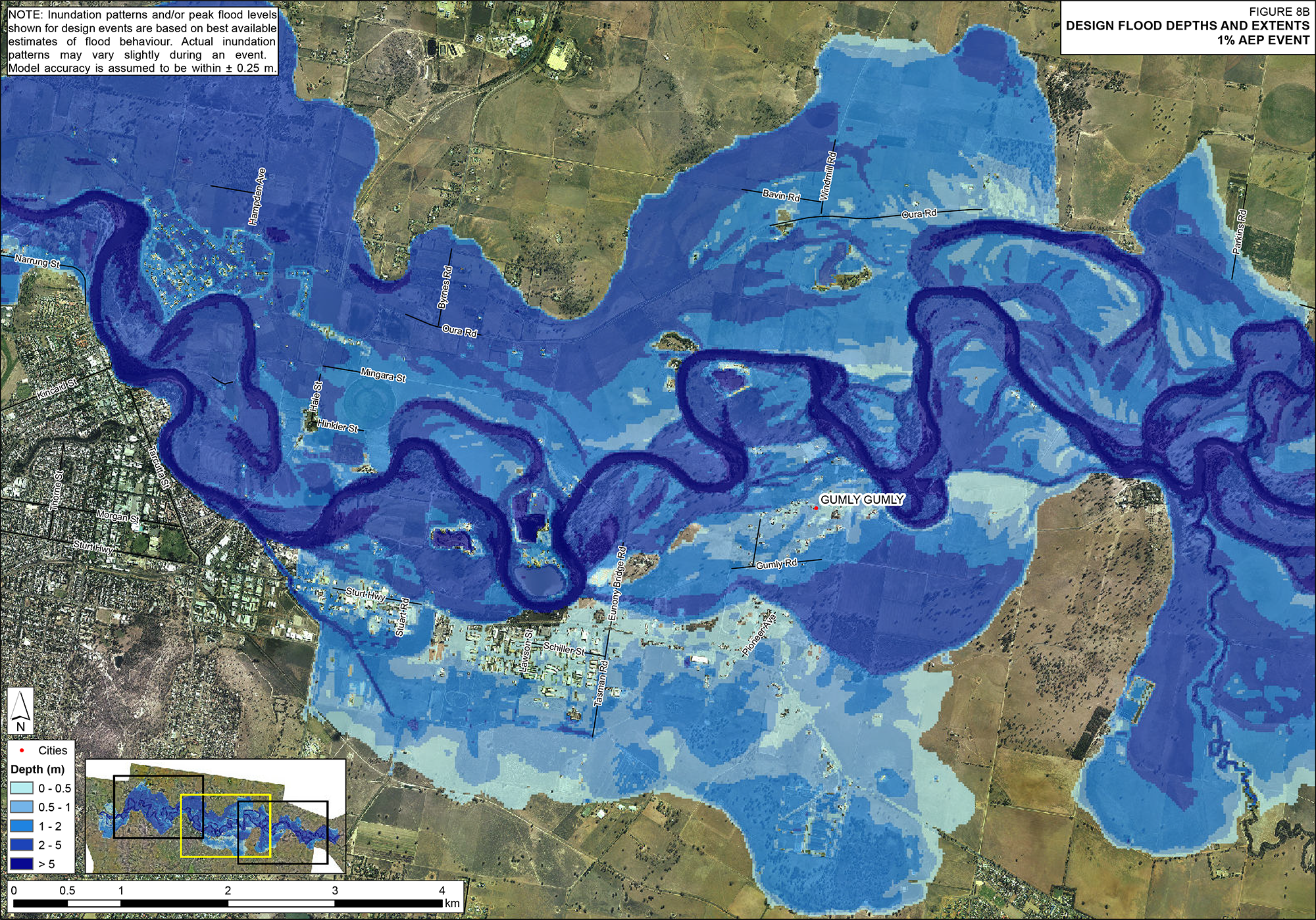
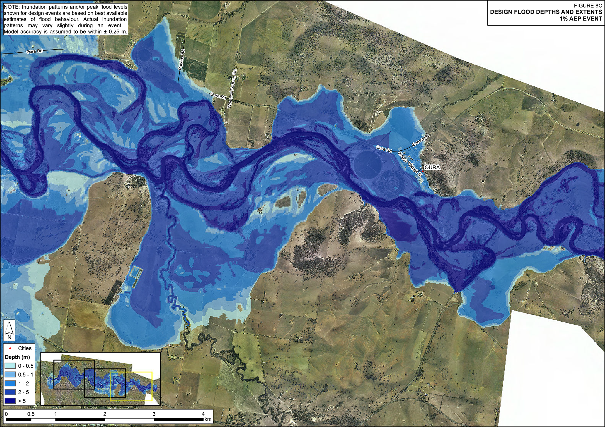
1% AEP Design Flood Depth and Extent
A 1% Annual Exceedance Probability (AEP) flood event is equivalent to a 1 in 100 year flood, which is a major rain event that occurs on average once every 100 years (i.e. there is a 1% chance of a flood this size or larger occurring at a particular location in any given year).
However, as we are continually reminded, the environment does not conform to mathematical formulas and therefore a 1% AEP will occur whenever nature decides.
The below images and document outline the flood depths and extent of a 1% AEP Flood in Wagga Wagga.
Figure 8 - Wagga 1% AEP Design Flood Depths and Extent 2.1 MB Download
Probability of experiencing a given-sized flood in an 80 year period
The following table outlines the probability of experiencing the below flood sizes in an average 80 year lifetime. For reference, the 2012 flood that peaked at 10.56m had an AEP % of approximately 2.85%.
| Annual Exceedance Probability (%) | Approximate Average Recurrence interval (years) | At least once (%) | At least twice (%) |
|---|---|---|---|
| 20 | 5 | 100 | 100 |
| 10 | 10 | 99.9 | 99.8 |
| 5 | 20 | 98.4 | 91.4 |
| 2 | 50 | 80.1 | 47.7 |
| 1 | 100 | 55.3 | 19.08 |
| 0.5 | 200 | 33 | 6.11 |
| 0.2 | 500 | 14.8 | 1.14 |
| 0.1 | 1000 | 7.69 | 0.30 |
| 00.1 | 10000 | 0.80 | 0.003 |
Riverine Flood Studies
Appendix A - Glossary 220.5 KB Download
Appendix B - Initial Community Consultation (Aug-Sept 2016) 212.3 KB Download
Appendix C - Flood Damages Assessment 334.5 KB Download
Appendix D - Hydraulic Categorisation - Floodway Definition 3.8 MB Download
Appendix E - Management Options Mapping 17.1 MB Download
Appendix F - Management Options Details and Costings 1.3 MB Download
Appendix G - Future Flood Risk Management 4.2 MB Download
Appendix H - Vegetation Management Plan 11.6 MB Download
Appendix I - SES Flood Intelligence Draft Updates 543.1 KB Download
Appendix J - Emergency Management Considerations for raising North Wagga Levee 806.6 KB Download
Appendix L - Alternate North Wagga Evacuation Route 727.6 KB Download
Appendix M - Responses to Public Exhibition Submissions 655.0 KB Download
Figure 1 - Study Area 341.0 KB Download
Figure 2 - Key locations and floodplain communities 1.6 MB Download
Figure 3 - Wagga Wagga City Council LEP - 2010 8.1 MB Download
Figure 4 - Wagga Wagga 0.5EY Design Flood Depths and Extent 2.3 MB Download
Figure 5 - Wagga 10% AEP Design Flood Depths and Extent 2.2 MB Download
Figure 6 - Wagga 5% AEP Design Flood Depths and Extent 2.2 MB Download
Figure 7 - Wagga 2% AEP Design Flood Depths and Extent 2.1 MB Download
Figure 8 - Wagga 1% AEP Design Flood Depths and Extent 2.1 MB Download
Figure 9 - Wagga 0.5% AEP Design Flood Depths and Extent 2.0 MB Download
Figure 10 - Wagga 0.2% AEP Design Flood Depths and Extent 2.0 MB Download
Figure 11 - Wagga PMF Design Flood Depths and Extent 1.8 MB Download
Figure 12 - Hydraulic Categorisation - 1% AEP Event 1.8 MB Download
Figure 13 - Hydraulic Categorisation - 5% AEP Event 1.9 MB Download
Figure 14 - Hydraulic Hazard - 1% AEP Event 11.2 MB Download
Figure 15 - Hydraulic Hazard - 5% AEP Event 11.7 MB Download
Figure 16 - Emergency Response Planning Classification - 1% AEP Event 3.8 MB Download
Figure 17 - Emergency Response Planning Classification - PMF Event 3.6 MB Download
Figure 18 - Flood Planning Area - Post Levee Upgrade 1.7 MB Download
Wagga Wagga LGA Murrumbidgee River Flood Modelling Report 2012 438.0 KB Download
Wagga Wagga LGA Murrumbidgee River Flood Modelling Report 2012 - Figures 1-7 9.9 MB Download
Wagga Wagga LGA Murrumbidgee River Flood Modelling Report 2012 - Figures 7b-7c 9.5 MB Download
Wagga Wagga LGA Murrumbidgee River Flood Modelling Report 2012 - Figures 7d 3.0 MB Download
Wagga Wagga LGA Murrumbidgee River Flood Modelling Report 2012 - Figures 7e 13.3 MB Download
Wagga Wagga LGA Murrumbidgee River Flood Modelling Report 2012 - Figures 8-10a 3.5 MB Download
Wagga Wagga LGA Murrumbidgee River Flood Modelling Report 2012 - Figures 10b 4.6 MB Download
Wagga Wagga LGA Murrumbidgee River Flood Modelling Report 2012 - Figures 10c-10d 7.6 MB Download
Wagga Wagga LGA Murrumbidgee River Flood Modelling Report 2012 - Figures 10e 13.1 MB Download
Wagga Wagga LGA Murrumbidgee River Flood Modelling Report 2012 - Figures 11a 3.5 MB Download
Wagga Wagga LGA Murrumbidgee River Flood Modelling Report 2012 - Figures 11b 4.6 MB Download
Wagga Wagga LGA Murrumbidgee River Flood Modelling Report 2012 - Figures 11c 4.7 MB Download
Wagga Wagga LGA Murrumbidgee River Flood Modelling Report 2012 - Figures 11d 3.0 MB Download
Wagga Wagga LGA Murrumbidgee River Flood Modelling Report 2012 - Figures 11e 13.3 MB Download
Wagga Wagga LGA Murrumbidgee River Flood Modelling Report 2012 - Appendix A 351.6 KB Download


